I read somewhere at some point about using the difference between resting morning and standing heart rates to assess fatigue level. Today, I finally found out that it's called Orthostatic Heart Rate, and also found a nice little article explaining it.
I use the following protocol:
Upon waking up, remain lying down, take my resting pulse for 30 seconds. Stand up using the minimum energy required and take my standing pulse for another 30 seconds. The difference between these will be my orthostatic rate.
Wednesday, October 17, 2018
Friday, June 15, 2018
Bike Infrastructure study on Copenhagen
A great Bike Infrastructure study on Copenhagen with Data Visualizations on the Guardian recently came out here.


Wednesday, June 13, 2018
Monday, May 7, 2018
North Cascades Highway 2018
My annual pilgrimage was successful this year. I was able to set some personal bests on the way up, and the road was clear for about 22 miles.
 |
| Looking down the Skagit river as it wends its way towards Puget Sound. |
 |
| Back down the plowed highway. |
 |
| Bike and snowplow. The last little bit up was only as wide as this plow - about 8 feet. |
 |
| I kind of wished I had dragged cross country skis up with me. |
As it turns out, the DOT ended up connecting the plowed sections the following week, and I got up there for the last weekend it was available.
Thursday, March 29, 2018
Spring and the North Cascades Highway
Here is a handy link to the WA DOT Twitter where they post updates on progress of the plowing of Highway 20.
Sunday, September 18, 2016
Exploring the Rhone Valley
https://www.strava.com/activities/644892051
https://www.strava.com/activities/645071483


This was the site of one of the very best meals I have ever had.

https://www.strava.com/activities/645071483


This was the site of one of the very best meals I have ever had.

Sunday, July 10, 2016
Climbing the Col du Tourmalet
This summer saw me fulfill some lifelong dreams, among them
getting the chance to climb the legendary, mythical Tourmalet. My new wife and I rode up from the St Marie de
Campan side of the beast, where Eugene Christophe had repaired his fork back in
the 1913 tour. Everywhere in France, it
seems, is covered with history.

The day was very hot, and Beth and I climbed at a slow pace,
stopping several times, including at the ski area of La Mongie. The gradient, once underway, is brutally
unrelenting, with the road’s km markers always letting you know what you are in
for over the next km. Most of the way up
is fairly wooded and covered; however, the forest opens up above La Mongie into
Pyrrenean meadows as the road twists and winds its way up.
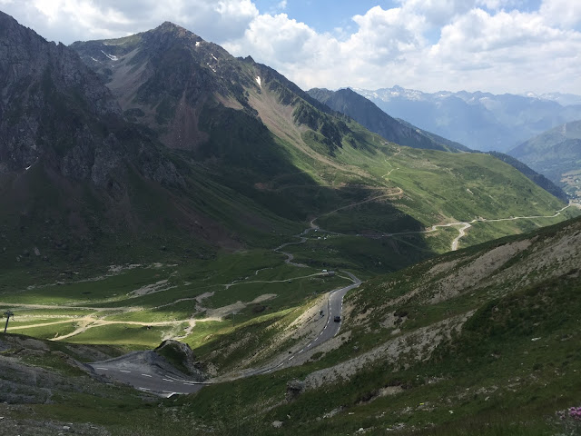
In the forested section below, the road is mostly straightforward, but higher up and it twists and turns the way good mountain roads so often do.

The clouds were rolling in as we descended, and a couple of hours later, the area erupted with violent thunderstorms bringing hail the size of sugar cubes. We were both very glad to be sheltered and eating at a fine restaurant by this time.


In the forested section below, the road is mostly straightforward, but higher up and it twists and turns the way good mountain roads so often do.

 |
| One can just make out the La Mongie Ski station at the center of the picture. |
At the top, there are placards and monuments announcing the history
of the place, as well as a souvenir shop selling jerseys and other trinkets.
 |
| The Octave Lapize memorial at the top. |
The clouds were rolling in as we descended, and a couple of hours later, the area erupted with violent thunderstorms bringing hail the size of sugar cubes. We were both very glad to be sheltered and eating at a fine restaurant by this time.
Subscribe to:
Posts (Atom)